


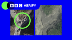
Satellite imagery has provided a stark visual testament to the widespread destruction caused by recent flooding across villages in Nepal. Comparisons of satellite photos taken before and after the deluge clearly illustrate the immense scale of the damage. The images depict entire villages inundated and irrevocably altered by the raging floodwaters. Crucially, the visuals also highlight the destruction of numerous bridges, severing vital transportation links. A significant border crossing between Nepal and Tibet has also been severely impacted, raising concerns about trade and transit. These before-and-after comparisons offer an undeniable perspective on the catastrophic impact of the floods on infrastructure and communities.
Satellite images reveal scale of flood devastation in Nepal villages


- Advertisment -